

 Back
hike
Back
hike
Snowshoeing itinerary: Les Arponts

A fairly strenuous winter hike through a quiet, untouched forest, reaching the Arponts plateau at an elevation of 1,900 meters.
Description
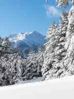
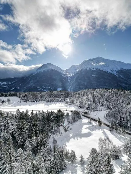
Beautiful panoramic views of the village and resort of Aussois, the surrounding peaks such as the RateauAussois, and views of the Maurienne Valley, its resorts, and peaks.
Additional welcome
Check the weather conditions and avalanche risk before you set out (weather services, mountain rescue services, professionals, tourist office...).
Make sure your gear and clothing are appropriate for the forecast.
Postpone your activity if the weather forecast is poor. Follow safety instructions and do not stray from marked trails in winter.
Environments
-
 Mountain view
-
Mountain location
-
10 - 20 min from a train station by car
-
Less than 10 minutes from a bus stop on foot
-
10–20-minute walk to the bus stop
Rates
Free access.
Itinerary
-
 Distance
7.2 km
Distance
7.2 km
-
 Route type
LOOP
Route type
LOOP
-
 Elevation gain
400m
Elevation gain
400m
-
 Negative gradient
400m
Negative gradient
400m
-
 Daily duration
4:00 a.m.
Daily duration
4:00 a.m.
-
 Signposted itinerary
Yes
Signposted itinerary
Yes
-
 Beaconing accuracy
Signposted Route 4
Beaconing accuracy
Signposted Route 4
-
Tricky passage
On the narrower section leading up to the hamlet of Prélatoute. In icy conditions, be sure to bring snowshoes or crampons,
as well as poles.
-
 Nature of the land
Non-groomed itinerary
Nature of the land
Non-groomed itinerary
-
 Maximum altitude
1910m
Maximum altitude
1910m
Opening period
Daily from December 15 to April 1.
Subject to favorable snow and weather conditions.
Additional opening
-
Subject to favorable weather
-
Subject to snow conditions
Labels
Location
As hazards may occur at any time on the routes, the GPX tracks provided are not contractual. They are provided for information only. Riders use them at their own risk, depending on their level of technological proficiency and their understanding of the terrain.

Animals
Pets allowed : Yes
Pets allowed with supplement: No
Out of respect for wildlife, please keep your dog on a lead.
Guidebook with maps/step-by-step
-
1/ From the Plan de la Croix parking lot, head north on Chemin de Jomier, which winds through snow-covered alpine pastures before entering the forest.
2/ 0 h 50 - At the junction after Le Raccourci, turn left onto the narrow path that leads to the hamlet of Prélatoute.
3/ 1 hr 45 min - At Prélatoute, after enjoying the panoramic views, continue up to Les Arponts d'en bas, then on to Les Arponts d'en haut, the highest point of the route (1,900 m).
4/ 2 hr 20 min - At Les Arponts d'en haut, turn right and follow the trail downhill along the clearing. The route continues on a forest track. At the Côte 1811 crossroads, turn carefully left and continue downhill to the Forêt des Arponts crossroads.
5/ 3 hrs 10 mins - At Forêt des Arponts, turn right to continue downhill on the forest track to the Jomier crossroads. From here, continue straight on toward Plan de la Croix.
6/ 3 hrs 30 mins - At the intersection with the uphill section of the route, continue straight ahead downhill on the forest track to return to the Plan de la Croix parking lot.
7/ 4 hrs - Plan de la Croix parking lot.


-
Distance
7.2 km
-
Daily duration
4:00 a.m.
-
Elevation gain
400m
-
Negative gradient
400m


-
Aussois
 trade and service
Bus stop N°600 : Plan de la Croix
-
Aussois
 trade and service
Bus stop N°604 : Le Centre
-
Aussois
 trade and service
Car park of the Cross
-
Aussois
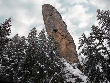 hike
hikeSnowshoe itinerary: The Monolith via...
- Distance 6.3 km
- Daily duration 02:30
- Elevation gain 180 m
- Elevation loss 180 m
-
Aussois
 hike
hikeSnowshoe itinerary: Jomier
- Distance 3.6 km
- Daily duration 2:00
- Elevation gain 180 m
- Elevation loss 180 m