

 Back
hike
Back
hike
Snowshoeing itinerary: The dams
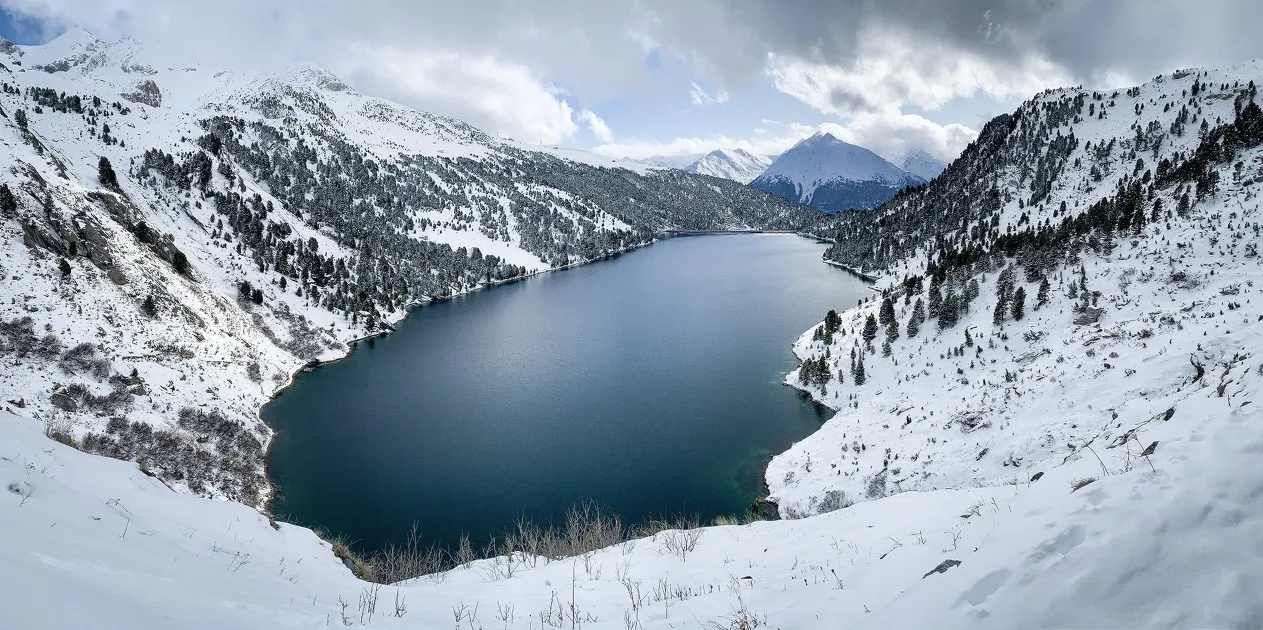
The Barrages route descends gently, gradually revealing superb views of the reservoirs and hydroelectric facilities in Aussois.
Description
Along the way, an icefall catches the eye, reminding us of the ever-present role of water in these high-altitude landscapes. Here, torrents, lakes, and dams bear witness to how this precious resource is preserved and transformed. A walk that invites us to see the mountains in a new light, both for their natural beauty and for the ingenuity they inspire.
Additional welcome
Check the weather conditions and avalanche risk before you set out (weather services, mountain rescue services, professionals, tourist office...).
Make sure your gear and clothing are appropriate for the forecast.
Postpone your activity if the weather forecast is poor. Follow safety instructions and do not stray from marked trails in winter.
Environments
-
 Mountain view
-
Mountain location
-
20 - 30 min from a train station by bike
-
Less than 10 minutes from a bus stop on foot
Rates
Free admission. The tour is free, but a valid lift pass is required to use the lifts.
Itinerary
-
 Distance
5.8km
Distance
5.8km
-
 Route type
One-way ticket
Route type
One-way ticket
-
 Elevation gain
10m
Elevation gain
10m
-
 Negative gradient
660m
Negative gradient
660m
-
 Daily duration
2:45 a.m.
Daily duration
2:45 a.m.
-
 Signposted itinerary
Yes
Signposted itinerary
Yes
-
 Beaconing accuracy
Signposted route no. 8
Beaconing accuracy
Signposted route no. 8
-
 Nature of the land
Non-groomed itinerary
Nature of the land
Non-groomed itinerary
-
 Maximum altitude
2185m
Maximum altitude
2185m
Opening period
Daily from December 15 to April 1.
Subject to favorable snow and weather conditions.
Additional opening
-
Subject to favorable weather
-
Subject to snow conditions
Labels
Location
As hazards may occur at any time on the routes, the GPX tracks provided are not contractual. They are provided for information only. Riders use them at their own risk, depending on their level of technological proficiency and their understanding of the terrain.

Animals
Pets allowed : No
Pets are not allowed on the lifts.
Guidebook with maps/step-by-step
-
1/ At the top of the Grand Jeu chairlift, turn left and follow the downhill ski slope, keeping a close eye on the side. Then cross the slopes to reach two small ski patrol huts.
2/ 0 h 10 - From the huts, take the groomed path that winds down to a viewpoint, passing through the Carrière 1 parking lot and then Plan d'Aval.
3/ 1 hr - After enjoying the view and reading the local information, continue on the groomed downhill path. After the two hairpin turns, take the right fork to enter the forest and reach the intersection at an elevation of 1,820 meters, at the foot of the ski slope.
4/ 1 hr 45 min - Cross the piste, then follow it for a few meters in the opposite direction of the skiers. The route continues to zigzag between the forest and clearings, joining a ski run at the hairpin bend.
5/ 2 hrs 30 mins - From this hairpin bend, follow the piste with care. Continue through two hairpin bends, then turn right at the last one to reach the finish.
6/ 2 hrs 45 mins - MaisonAussois


-
Distance
5.8km
-
Daily duration
2:45 a.m.
-
Elevation gain
10m
-
Negative gradient
660m


-
Aussois
 trade and service
Parking at the foot of the slopes
-
Aussois
 hike
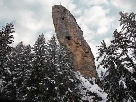
hikeSnowshoe itinerary: The Monolith via...
- Distance 6.3 km
- Daily duration 02:30
- Elevation gain 180 m
- Elevation loss 180 m
-
Aussois
 hike
hikeSnowshoe itinerary: Jomier
- Distance 3.6 km
- Daily duration 2:00
- Elevation gain 180 m
- Elevation loss 180 m